This post may contain affiliate links, from which we earn an income. Click here to read our affiliate policy.
The Pyrenees are one of France’s most rewarding regions for a road trip built around hiking. Stretching along the border with Spain, these mountains offer dramatic scenery, quiet valleys, and some of the best marked walking trails in Europe, often without the crowds or extreme elevation you might expect from an alpine range.
This Pyrenees road trip and hiking itinerary is designed as a 7–9 day journey, combining scenic driving with a series of achievable day hikes. It focuses on the central French Pyrenees, with classic bases like Cauterets, Gavarnie, and Bagnères-de-Luchon, before offering an optional extension into Spain’s Ordesa National Park for those with extra time and energy. Distances are short, the route is logical, and each day balances walking with recovery and travel time.
It’s an ideal itinerary for active travellers who want to explore the mountains properly without technical climbing or constant hotel changes. With well-maintained roads, clear trails, and a strong sense of place throughout, this route shows just how accessible and varied the Pyrenees can be by car and on foot.
Pyrenees Road Trip Map
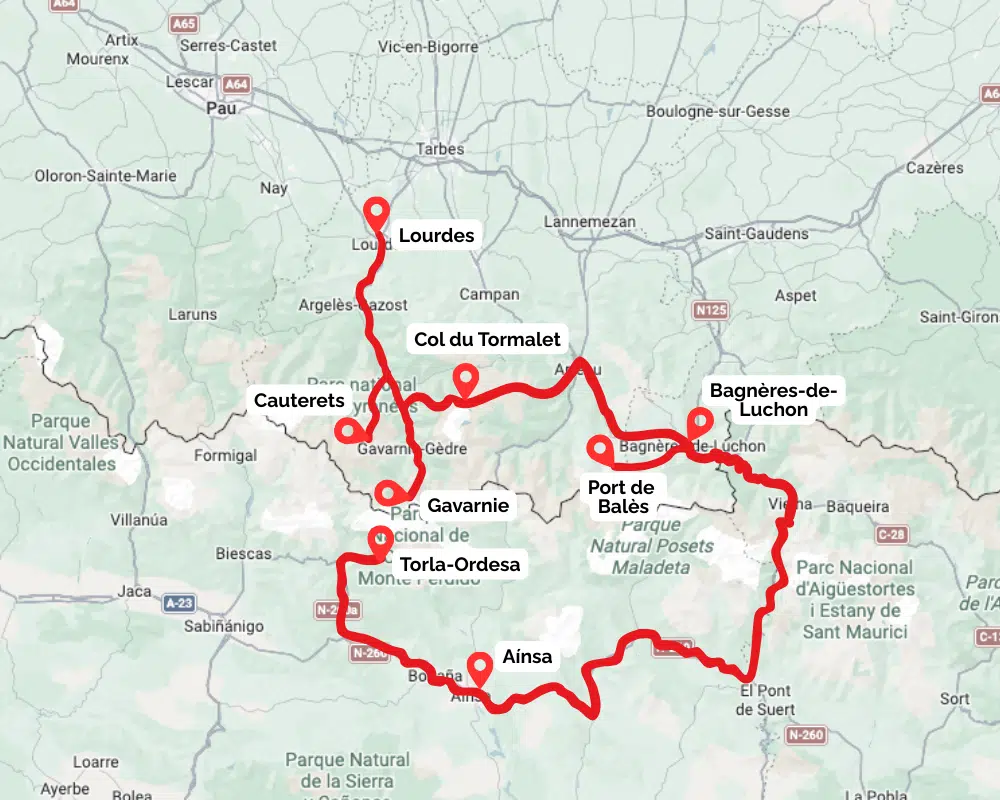
Route: Lourdes – Cauterets – Gavarnie – Col de Tentes – Col du Tourmalet – Port de Balès – Bagnères-de-Luchon (+ Ordesa, Spain optional)
Distance: ~280 km / 175 miles driving
Duration: 7 days (8–9 with Spain extension)
Best time to go: May, June, September and early October
Best for: Hiking, alpine scenery, scenic driving, thermal spas
A quick note on timing: Because many of the high passes are closed outside the summer season, this route doesn’t always plot cleanly in Google Maps during winter. We’ve shown the full route above instead, with individual stages becoming easier to map once the passes reopen.
Planning tools we actually use for France road trips
How to Get to the Pyrenees
The Pyrenees stretch along the border between France and Spain, but this itinerary is focused on the central French Pyrenees, with Lourdes, Cauterets, and Gavarnie as the main access points. The trip works best as a self-drive route.
Flying
The easiest airports for this itinerary are:
All have car hire available and straightforward onward driving into the mountains.
Driving
If you’re driving from elsewhere in France or Europe, aim for Tarbes or Lourdes as your entry point. From here, mountain towns like Cauterets and Gavarnie are around an hour away on well-maintained roads. Public transport exists between major towns, but trailheads, mountain passes, and accommodation are far easier to reach with your own vehicle.
The Best Time for Hiking in the Pyrenees
The best time to visit the Pyrenees for hiking is between May and October. Much earlier or later, and there will be snow above 2,000m (6,562ft), which will hinder some of the hiking opportunities, and may require you to fit snow chains to your car or camper.
July and August will be very busy with families hiking the easier trails. Accommodation and campsites will need to be booked in advance.
The perfect months for a Pyrenees hiking tour are May, June, September, and October. You’ll have perfect warm, but not hot weather, although it will be cool in the evenings, so make sure you have some warmer clothing with you.
How Fit Do You Need to Be for Pyrenees Hiking?
This itinerary is designed for regular walkers rather than experienced mountaineers. All of the hikes are graded easy to moderate, follow well-marked trails, and avoid technical terrain. You don’t need scrambling skills, ropes, or specialist mountain experience.
That said, you should be comfortable walking for 4–6 hours a day, sometimes on uneven ground, with steady but manageable elevation gain. Several routes are longer rather than steeper, so stamina matters more than strength or speed. Taking breaks, stopping for lunch, and turning back early are all completely normal parts of hiking here.
A few hikes include short steeper sections, and the Spanish extension to the Circo de Soaso is the most demanding day of the trip. If you’re unsure, you can shorten routes, skip higher viewpoints, or stick to valley paths without losing the overall experience. As always in the mountains, check the weather, carry layers, water, and food, and don’t hesitate to adjust plans if conditions or energy levels change.
Day 1: Lourdes to Cauterets
Driving time: ~1 hour from Lourdes
Focus: Arrival day, spa town, gentle orientation
Overnight: Cauterets
Cauterets is a classic Pyrenees mountain town and an ideal starting point for a week of hiking. It has everything you need without feeling overdeveloped: bakeries, cafés, outdoor shops, thermal baths, and easy road access into the surrounding valleys.
If you’re arriving via Lourdes or Tarbes, the drive is short and scenic, passing through wooded hills before the mountains begin to close in. If time allows, a brief stop in Lourdes is possible, but it’s busy and very different in tone to the rest of the trip, so many travellers prefer to continue straight into the hills.
Once in Cauterets, keep the day light and easy going. Wander the town, pick up trail snacks, and familiarise yourself with the road up to Pont d’Espagne, which you’ll use tomorrow. This is also a good moment to check weather forecasts and trail conditions, especially if you’re travelling early or late in the season.
If your legs need easing into things, the thermal baths are a perfect introduction. Otherwise, settle into a relaxed dinner and an early night. Tomorrow’s hike is one of the Pyrenees’ most famous, and it’s worth starting fresh.
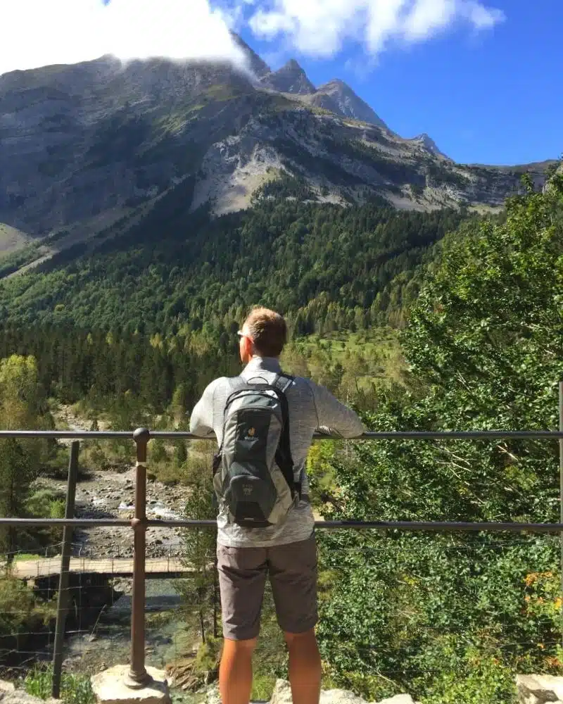
Day 2: Vallée de Gaube (Pont d’Espagne to Lac de Gaube)
Hiking distance: 8.4 km
Elevation gain: 340 m
Time: 2–3 hours
Route type: Linear
Difficulty: Easy–Moderate
Driving: 20 minutes from Cauterets
Overnight: Cauterets
Drive up through Cauterets on the D920 to the large car park at Pont d’Espagne. The area is well organised, with clear signage, dedicated motorhome parking, and access to the Lac de Gaube cable car if you want to shorten the walk.
From the visitor centre, follow the main path toward the waterfalls and the stone Pont d’Espagne bridge, where two torrents crash together in a dramatic series of cascades. This area is busy, but for good reason, and the trail infrastructure here is excellent.
Beyond the bridge, the route follows part of the GR10, climbing steadily through forest. The initial ascent is the steepest part of the walk, but it is well surfaced and never technical. As the valley opens up, views improve quickly, with the Vignemale massif dominating the skyline ahead.
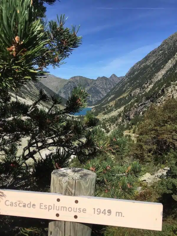
Lac de Gaube appears almost suddenly at 1,725 metres (5,659 ft), its still water reflecting the surrounding peaks. It’s an ideal lunch stop, and on warm days, hardy swimmers often brave the icy water. Facilities are basic but available.
If you want to extend the walk, continue south around the lake toward Cascade d’Esplumouse. The additional elevation is gradual rather than steep, and the waterfall makes a quieter, less crowded stopping point.
Return the same way, allowing time to pause at viewpoints you may have rushed past earlier. Back in Cauterets, this is a good evening for an early dinner or another visit to the baths.
Good to Know: This hike is inside the Pyrenees National Park. Dogs are not allowed, even on leads, and camping, fires, and drone use are prohibited.
Planning this hike? Read the full Vallée de Gaube trail guide with route details, parking tips, and seasonal advice.
Day 3: Cirque de Gavarnie
Hiking distance: 8.5 km (longer if approaching the waterfall)
Elevation gain: 210 m
Time: 4–5 hours
Route type: Linear
Difficulty: Easy–Moderate
Driving: ~1 hour from Cauterets
Overnight: Gavarnie or Gavarnie-Gèdre
Leave Cauterets early and drive west toward Gavarnie. The final approach gives you your first glimpse of the cirque’s immense limestone walls, which dominate the valley long before you reach the trailhead.
From the main car park in Gavarnie village, walk downhill into the centre and follow the signs south toward the cirque. The path is wide, mostly level, and suitable for a relaxed pace, making this one of the most accessible yet dramatic hikes in the Pyrenees.
As you follow the river, the cirque gradually reveals itself. Waterfalls spill down vertical cliffs, wildflowers fill the meadows in spring and early summer, and grazing animals are a constant presence. The scale of the landscape is the real highlight here, rather than a physical challenge.
The final approach toward the Grande Cascade involves a steeper, shale-covered ascent. You can stop below if you prefer; those who continue all the way to the base of the waterfall should take care on the loose surface, especially on the descent.
Return the same way, allowing time to stop for lunch or a drink at the Hôtel du Cirque near the end of the valley. Staying overnight in Gavarnie is strongly recommended. The cirque feels completely different in the early morning and evening, once most visitors have left.
Good to Know: This is a UNESCO World Heritage Site and part of the Pyrenees National Park. Dogs are not permitted, and facilities beyond the Cirque de Gavarnie Hôtel are extremely limited.
Want more detail? This full Cirque de Gavarnie hiking guide covers route options, photos, and practical tips.
Day 4: Port de Boucharo & Pic de la Pahule
Hiking distance: ~5 km / 3.1 miles
Elevation gain: ~120 m / 395 ft
Time: 2–3 hours total
Route type: Linear out-and-back
Difficulty: Easy
Driving: Short mountain drive to Col de Tentes
Overnight: Gavarnie or Gavarnie-Gèdre
After two full hiking days, this stage is deliberately lighter, giving your legs a break without sacrificing scenery.
Drive south from Gavarnie on the D923, passing ski stations and lift infrastructure before reaching the Col de Tentes car park, where the road ends. This high-access point makes the area feel surprisingly open and relaxed, even though you’re deep in the mountains.
From the car park, the walk to Port de Boucharo is wide, well-defined, and gently graded. The path follows a historic crossing point at the French–Spanish border, with long views back toward the valleys of Luz-Saint-Sauveur and across to the Spanish Pyrenees. It’s an excellent option if the weather is mixed or if you want a calmer morning.
Back at the car park, a short but steeper climb leads to Pic de la Pahule. The ascent is brief but rewarding, opening up 360-degree views across the surrounding peaks. An orientation table at the summit helps identify major landmarks, and this is one of the best spots on the itinerary for a quiet lunch with a view.
This day works as both an active recovery day and a scenic reset before the longer driving stage tomorrow.
Good to Know: It’s possible to ride from Gavarnie to Col de Tentes on an e-bike, which you may be able to hire from your hotel. It’s often busy due to the excellent accessibility: the track to the Port is partly wheelchair friendly. There are sometimes coach parties here, but the surrounding hikes are so many and the area so huge, they just disappear into the landscape!
Planning this hike? Read the full Port de Boucharo and Pic de la Pahule trail guide for route notes and seasonal conditions.
Day 5: Scenic Drive via Col du Tourmalet to Port de Balès
Focus: Driving one of the most iconic mountain roads in France
Hiking: Optional short walks only
Overnight: Port de Balès / Bourg-d’Oueil area
Today is about the drive rather than the steps.
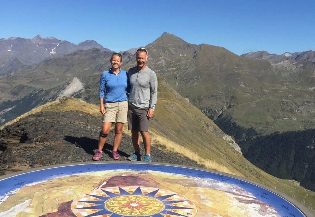
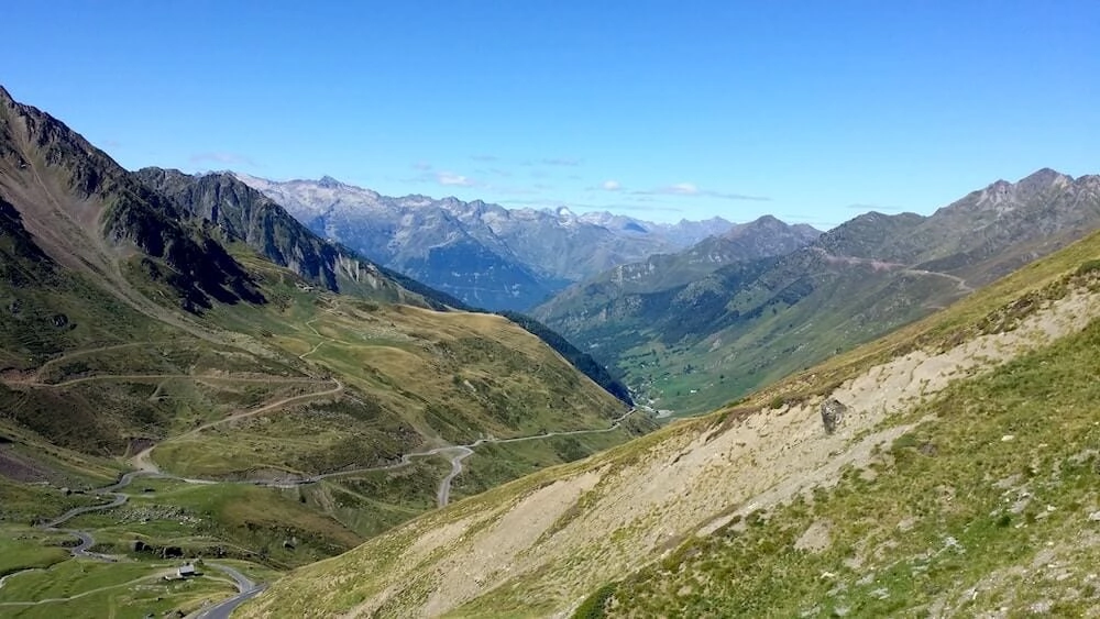
Leave Gavarnie heading north through Luz-Saint-Sauveur before joining the D918 toward the Col du Tourmalet, one of the most famous mountain passes in the Tour de France. The road climbs steadily, with wide switchbacks and increasing exposure as you gain height.
Your sat nav may want you to continue along the D921 back to Lourdes, but this route will take you over five hours to get to Port Balès, and you will miss the jaw-dropping Col de Tourmalet and the incredible views of the Pic du Midi, the highest peak in the Pyrenees.
At the summit, views stretch across the central Pyrenees, with the Pic du Midi de Bigorre dominating the skyline. Even non-cycling fans will recognise the landscape from countless race images. It’s a natural lunch stop, whether you eat in the car or at one of the simple cafés near the top.
From here, descend carefully and continue east toward the quieter, more remote Port de Balès. This section feels wilder and less polished, with fewer services and far less traffic. Fuel up and buy supplies earlier in the day, as options become sparse.
No major hike is planned today, but short walks near the pass or evening strolls around your accommodation help loosen tired legs.
Good to Know: These are good roads, although there are some areas with steep drop-offs and no barriers, so consider how you feel about this before taking this route. There are a lot of hairpin bends on the way up and down, but we managed this in an 8m motorhome with a bike rack with no concerns.
Day 6: Mont Né & Lac de Bareilles
Hiking distance: ~12 km / 7.5 miles
Elevation gain: ~640 m / 2,100 ft
Time: 4–5 hours
Route type: Circular
Difficulty: Easy–Moderate
Driving: Short mountain drive to Port de Balès
Overnight: Port de Balès / Bourg-d’Oueil area
This is one of the most rewarding hikes of the itinerary, combining open ridgelines, wide views, and a high-altitude lake.
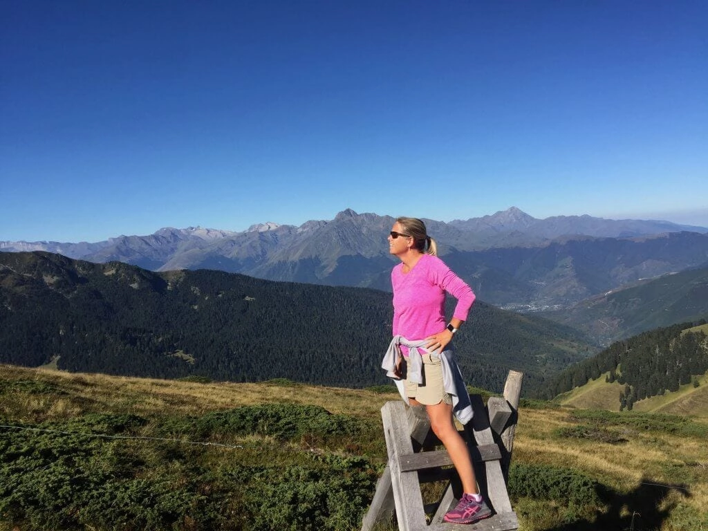
From the Port de Balès car park, follow the clear track uphill before branching onto a narrower path that climbs steadily toward Mont Né. The ascent is sustained but never technical, with grassy slopes giving way to more open, rocky ground as you approach the ridge.
The summit sits at 2,147 m / 7,044 ft and offers expansive views across the Pyrenees, including several 3,000 m+ peaks on clear days. Large cairns mark the top, making it a natural rest point before continuing along the ridge.
From here, descend toward Lac de Bareilles, a high mountain lake tucked below the ridge. In summer, it’s a popular wild swimming spot, though the water remains cold even on warm days. The lakeside makes an ideal lunch stop, sheltered and scenic.
The return route follows an old paved track back toward the pass, offering gentler gradients and long views down the Vallée d’Oueil. It’s a satisfying loop that feels varied without being exhausting.
Good to Know: Cars and motorhomes can park at Port de Bales at 1755m / 5758 ft at the foot of Mont Né. In summer, there is a small van serving hot drinks, crepes, and waffles, but there are no toilet facilities.
Planning this hike? Read the full Mont Né and Lac de Bareilles hiking guide for route options and parking advice.
Day 7: Bagnères-de-Luchon: Thermal Baths & Recovery
Driving time: ~30–40 minutes from Port de Balès
Focus: Recovery, town wandering, optional short walks
Overnight: Bagnères-de-Luchon
After several high-mountain days, today deliberately slows the pace.
Drive east to Bagnères-de-Luchon, one of the Pyrenees’ classic spa towns. Known simply as Luchon, it has long attracted hikers, cyclists, and Tour de France teams thanks to its thermal waters and mountain setting.
The main draw is Les Thermes du Luchon, where sulphur-rich waters are used for both relaxation and rehabilitation. Even a simple soak makes a noticeable difference after days on the trail.
Spend the rest of the day wandering the tree-lined boulevards, browsing outdoor shops, and enjoying an unhurried meal. If you want to stay lightly active, there are short valley walks and gentle riverside paths nearby, but nothing today is compulsory.
This overnight stop resets both legs and mindset before the optional Spain extension.
Day 8: Luchon to Torla-Ordesa (Spain)
Driving time: ~3.5–4 hours (excluding stops) from Luchon
Focus: Scenic border crossing, positioning for Ordesa
Overnight: Torla-Ordesa
Today is a long but scenic cross-border drive, moving from the French Pyrenees into northern Spain. Rather than rushing, it works best as a travel-focused day with one well-chosen stop.
About halfway through the drive, Aínsa makes an excellent break. This beautifully preserved medieval town sits above the confluence of the Cinca and Ara rivers and feels like a natural gateway to the Spanish Pyrenees. The compact old town is easy to explore in under an hour, with stone streets, a broad central plaza, and views toward Ordesa and Monte Perdido. It’s a good place for lunch, a short wander, and a mental reset before the final stretch to Torla.
From Aínsa, the drive continues north through increasingly dramatic mountain scenery before arriving in Torla-Ordesa in the late afternoon, well positioned for an early start into Ordesa National Park the following day.
Day 9: Circo de Soaso (Ordesa National Park)
Hiking distance: ~22 km / 13.8 miles
Elevation gain: ~650 m / 2,130 ft
Time: 6–7 hours
Route type: Circular
Difficulty: Moderate–Hard
This is the big finale hike of the itinerary and deserves a full, unhurried day.
From Torla, take the shuttle bus to the Pradera de Ordesa trailhead, as private vehicles are restricted during much of the season. The hike begins with a steady climb above the valley on the Sendero de los Cazadores, a switchback path that gains height quickly and offers dramatic views back toward the canyon floor.
Once on the high Faja de Pelay path, the trail traverses along the valley walls, opening up extraordinary views of Monte Perdido and the surrounding cliffs. After reaching the mirador, the route levels out and becomes more relaxed, allowing you to take in the scale of the landscape without constant climbing.
Descending into the Circo de Soaso, the trail leads to the Cola de Caballo waterfall, a powerful cascade that marks the natural turnaround point. This is an ideal lunch stop before returning via the valley floor, following the Arazas River past a series of waterfalls and clear pools.
The return route is long but gentler, with minimal elevation gain and frequent rest spots. Expect a full day on the trail.
This hike is optional but exceptional. If you include it, it feels like a true conclusion to the Pyrenees journey, expanding the trip beyond France without overcomplicating the route.
Good to Know: This UNESCO World Heritage Site and UNESCO Biosphere Reserve is one of the oldest national parks in the world and was Spain’s first protected area, established in 1918. Treat the flora, fauna, and environment with respect and leave no trace of your visit.
Planning this hike? Read the full Circo de Soaso trail guide for route options, shuttle details, and safety notes.

Where to Stay on a Pyrenees Itinerary
This Pyrenees itinerary is designed as a point-to-point road trip, with accommodation aligned to each day’s hike or driving stage. Staying close to trailheads reduces early starts, avoids unnecessary backtracking, and gives you flexibility if weather changes.
Where possible, options include hotels and campsites, as this region is particularly well set up for both.
Days 1–2: Cauterets (Vallée de Gaube Base)
Mid-range: Hôtel Le Bois Joli is a welcoming mountain hotel close to the town centre and cable cars, offering comfortable rooms and a relaxed, hiker-friendly atmosphere. It’s a reliable base for exploring the Vallée de Gaube.
Budget: Camping Cabaliros sits just outside Cauterets and offers good facilities, small cabins, and a free shuttle into town. It’s practical, affordable, and well-suited to hikers and campervan travellers.
Days 3–4: Gavarnie–Gèdre (Cirque de Gavarnie Base)
Mid-range: Hotel Le Taillon is a simple but well-run mountain hotel with excellent views and hearty regional food. Its location makes early starts to the Cirque de Gavarnie easy and stress-free.
Budget: Camping Les Tilleuls is centrally located in Gavarnie and offers pitches, cabins, and good facilities. There is also a motorhome aire on the D923 just outside the village for those travelling by camper.
Days 5–6: Bourg-d’Oueil / Port de Balès Area
Mid-range: Hôtel Le Sapin Fleuri in Bourg-d’Oueil is the closest hotel to the Port de Balès trailhead, just a short drive away. It’s quiet, rural, and ideally placed for hiking Mont Né.
Budget: Wild camping at Port de Balès is popular with campervan travellers and offers a peaceful overnight stop with wide mountain views. There are no facilities, but the setting is exceptional.
Day 7: Bagnères-de-Luchon
Luxury: Le Castel d’Alti is a refined spa hotel in an elegant historic building, perfect for easing tired muscles after several hiking days. Its central location makes exploring Luchon on foot easy.
Budget: Camping Au Fil de l’Oô is well equipped and centrally located, making it a practical base for enjoying the town and thermal baths. It’s a good reset point before crossing into Spain.
Day 8–9: Torla-Ordesa (Ordesa National Park Base, Spain)
Luxury: Hotel Bujaruelo is a comfortable mountain hotel with an excellent restaurant and a calm atmosphere, ideal for resting before and after the Circo de Soaso hike.
Mid-range: Hotel Edelweiss is centrally located in Torla and offers reliable comfort, parking, and easy access to the Ordesabus shuttle into the national park.
Budget: Camping Río Ara sits just outside Torla and offers pitches, cabins, and simple rooms. It’s quiet, practical, and well-positioned for early starts into Ordesa National Park.
Booking Tips for a Pyrenees Road Trip & Hiking Itinerary
Accommodation in the Pyrenees is more limited than in coastal or city-based regions, especially in smaller mountain towns like Gavarnie and around Port de Balès. Booking ahead makes a big difference to how smoothly the trip runs.
Road Trip Tips for the Pyrenees
This route is straightforward to drive, but mountain conditions and seasonal closures mean a little planning goes a long way.
What Kit Do You Need for Pyrenees Hiking?
You will need the following for day hiking in the Pyrenees mountains between May and October:
More France Road Trips to Explore
Motorhoming in Portugal: Your Complete Guide

Motorhoming in Turkey: The Ultimate Guide to Planning Your Trip
Campervan Rental Albania: The First-Time Traveller’s Guide to Beaches, Mountains and an Epic Road Trip
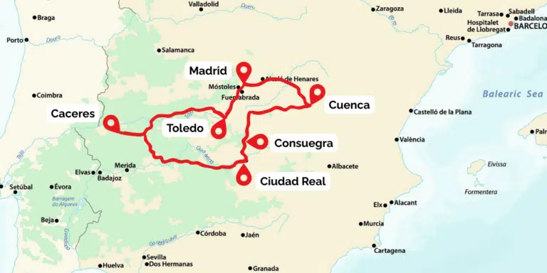
Road Trip from Madrid: 7–10 Days Central Spain Loop
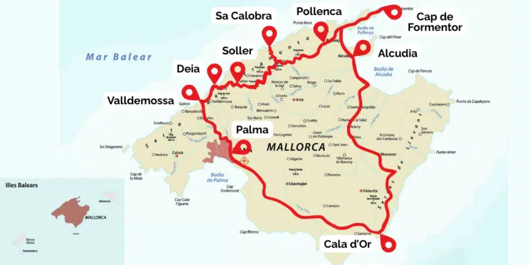
Mallorca Road Trip: 7–10 Day Island Loop from Palma
Catalonia Road Trip: 7–10 Day Costa Brava & Pyrenees Loop from Barcelona
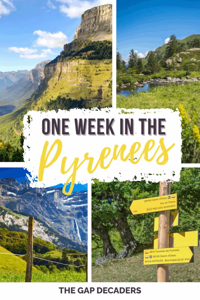
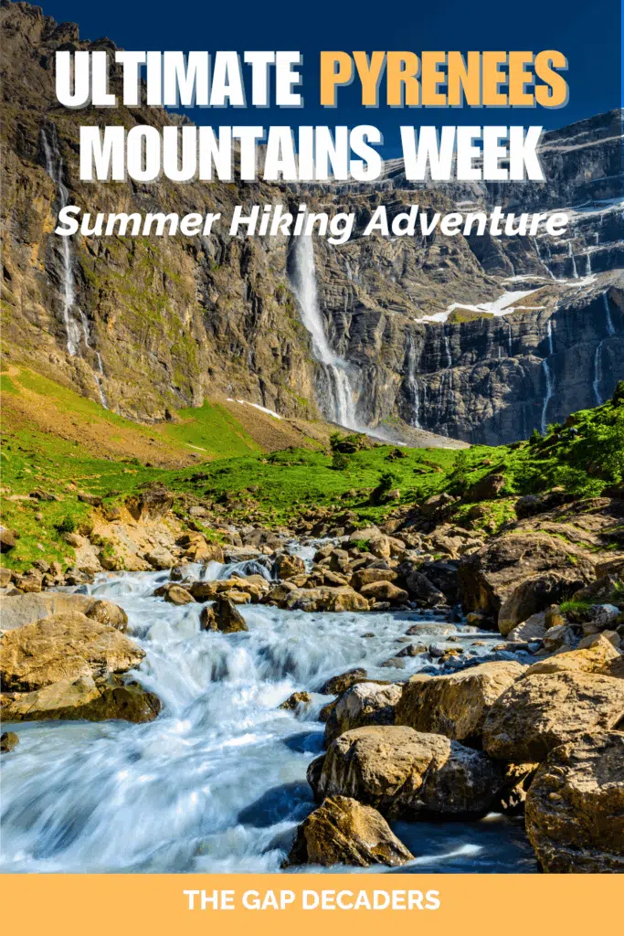
Love it? Pin it!